Wednesday, May 8, 2013

Final blog


3rd Blog Post 
May 8-2013

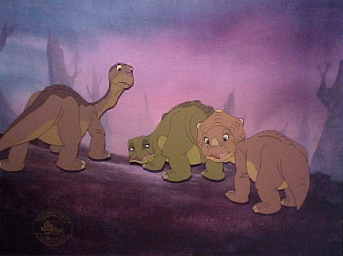
In the picture above, behind the dinosaurs there is a long stream of water. Due to the fact that there is rocks surrounding the river it is assumed that the river is carrying a load. From the look of the rocks surrounding and what looks to be a large desert, the stream is carrying a large bed load  A bed load is sediment transported along the bed of a river by sliding rolling or hopping. As you can see the rocks on the side have been moved by the stream and the stream continues to move particles down its flow. Bed loads often occur where there is steep gradients in the land. This is also one of the biggest reasons that this river was formed. This is not a suspended load as the particles are not flowing at the same velocity as the river. So what will this scenery look like in a million years? In fact this river will not be here, all the land will be a large desert. I assume this will happen in a million years because this picture shows all the characteristics that lead to a warm dessert. Also the climate in the background looks gloomy which is always in result to rain shadow. The last reason I believe this land will turn to desert is because of the mountains in the background which like the Andes mountains could be blocking moisture sources from the other side. In one million years I am almost sure that this long stream of water surrounded by the mountains and dirt will evaporate and no longer exist. 


It is definitely obvious that in this image above the area is far away from moisture source, which means it is in extreme continentality. This is one main cause of a warm desert. Due to the dry climate it will result in less transpiration and evaporation which equals in no cooling. Eventually the heat will gather with the wind forming convection on the bare rocks. The wind blows sediment off the rocks causing deflation which is erosion by wind of loose material from flat areas of dry, uncemented sediments. The trees are dead due to lack of water and get rain shadow because of the mountains that are in the background. But this climate could eventually flip upside down in a million years creating a huge valley of water from an ice age which was told by scientists to be the cause of extinction of the dinosaurs. This would have created the valley to blend in with the mountains forming glaciers of ice and completely changing the whole climate of this area.  

http://images1.wikia.nocookie.net/__cb20081122050038/landbeforetime/images/1/13/Cap006.JPG

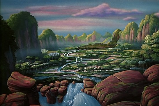
The image above shows a large flat terrace with a drop off to a sandy area leading to some water. The terrace was created from when the sea level was higher and waves were crashing on that area of land, causing it to flatten out as it looks in the picture. After the waves smoothed and flattened the land, the sea levels decreased for one reason or another, leaving the flat terrace the characters stand on in this picture. People might think that the sea level decreased because it was getting hotter, but that can't be true because of the really green landscape. It actually might have been the exact opposite, it was getting colder. It was getting colder and glaciers around the area might have been accumulating, or gaining ice, a lot more than there were melting, causing surrounding areas or water to be sucked up and resulting in the decrease in sea levels and showing many new marine terraces or platforms like the one depicted above. As I previously said the above picture actually shows temperature getting colder as glaciers are accumulating, so in 1000 year patterns would persist and more and more water froze up the would be more massive glaciers and tons of more platforms like the one above showing the different sea levels at different times. 10,000 years from now, because the climate was getting colder and colder, the area would be in the early stages of an ice age with everything covered in snow, shown in following movies, and correlating the the hypothesis scientist use as why dinosaurs are extinct. One million years from now the ice age would be similar to the one we are in today, warmer weather and recovery and tons of land and vegetation and rise of sea levels, but still relatively cooler temperatures than there were before. 

Thursday, April 18, 2013

April 2013


http://media.tumblr.com/tumblr_lqjfq0FgMq1qm06i9.gif

The image above involves a thunderstorm which is only possible with unstable air mass and moisture to form clouds. Thunderstorms are divided into stages, for example the mature stage which results in a lot of updraft. The current stage that we see in the image is a Gus front which is caused from heavy rain and frequent lightning. As time passes the thunderstorm will eventually go through a dissipating stage which is developed through rain-cooled air flows.


http://i547.photobucket.com/albums/hh475/Malte279/The%20Land%20before%20Time/The%20Cold%20Time/02Strugglingthroughtheblizzard.jpg 

The picture above depicts two characters having a hard time walking against a strong wind. The wind coming from in front of them and moving behind them shows that there must have been high atmospheric pressure in front of them and low atmospheric pressure behind them. This is in agreement with the third law of geography which states that air always flows from high pressure to low pressure. The wind being so strong in the picture indicated that there must have been steep pressure gradients, or many different air pressures over a short distance, because steep pressure gradients cause the strongest winds.


http://www.animationsensations.com/img/dinosaur2.jpg

The picture above shows three of the characters walking through a big area of fog. Due to the fact the it had just rained in the previous scene, this fog is probably radiation fog, which require a lot of moisture in the ground, such as right after it rains. It also requires that there is no wind so that it can collect. The ground starts cooling by conduction, meaning that the cold air near the ground comes in contact with other air molecules and cools them down as well. This conduction continues until the dew point is reached, which is when humidity is at 100% meaning that the air is saturated with the most moisture. The radiation for would eventually clear by either evaporation or when a wind comes in and disperses it.

Tuesday, February 19, 2013

Land Before Time


http://images2.wikia.nocookie.net/__cb20080419071355/landbeforetime/images/9/9e/Found_the_Great

Hey my name is Freddie Magana, my classmates TJ Jad, Cameron Bough and I have decided to team up to report the land changes at fascinating characteristics of the landscape from the movie the Land Before Time. We decided to choose this location because even though it is a real old fictional movie, it still contains many relevant and accurate geography references that we could apply to what we are learning in class.

https://blogger.googleusercontent.com/img/b/R29vZ2xl/AVvXsEhsJg0EwEF3Tn5MHlnDwPKd7x-HlhpBRQNqGn-LNG70b_g8sSvc9NRzpkt-bezdJMeEeE0JDWb4rLv-x7KFfefTnB-sGFSClCbcgDJJgdjS5IU9OUKymcAirrNv1XqpAfVr91xeraKvQRw/s1600/LAND_BEFORE_TIME_XIII_title01145_00.jpg

Throughout the course of the movie, about every scene is related to something we learned in class. From the beginning to the end land forms such as Volcanoes  Continental drifts and earth quakes take place. In the picture above behind the two characters you can see a screenshot from the movie. In the background you can see the after math of a right strike fault. In the movie after days of travel the earth starts to crack due to plate tectonics grinding.

http://images3.wikia.nocookie.net/__cb20080902003136/landbeforetime/images/0/04/COMV.jpg

The picture above shows a rock wall which looks a little bit deformed. This was most likely created by the process of folding. This is caused by the compression of two plates moving toward each other, which cause the rock to fold on top of itself, giving it the look of going one direction and then the complete opposite direction. This type of fold would be classified as a syncline.


The video clip above shows two tectonic plates pulling away from each other causing an earthquake. This type of plate interaction is divergence. Eventually towards the end of the earthquake lava can be seen shooting from between the space between the moving plates. This is also accurate with the process of divergence because it usually involves lava coming between the newly created openings to create new land.


The little ledge that she keeps running into could have been from a fault through extension. The ground pulled apart and most likely descended in level, causing the little drop off. You can tell the land pulled apart to make the drop off because of what is sharing the two different elevations of land. There is a tree in the middle of two different levels of land and you can tell the tree originally grew on the top piece of land because all of the roots are exposed on the bottom half. The area that she keeps running into would be classified as a scarp which is often times created when extensions happen at faults.


March 11, 2013

http://www.rickbentham.com/animation/land_before_time/The_Land_Before_Time_Background_1.jpg
The picture above demonstrates rock decay in the form of weathering. This is the breaking down of rock which can be due to altitude, climate or location.  At one point in time these rocks were in one large strong peace but over time because of the joints and cracks in the rock, physical weathering has entered and caused the rock to decay. These cracks can be caused from thermal expansion, frost weathering or pressure release. In this picture because the weather looks like it can be either hot or cold the cracks in the rock most likely formed from frost weathering. Upon freezing the rock increases its volume. The water inside freezes causing the ice and the rock to expand resulting in high pressures and fracturing the outside of the rock. The rocks that are falling represent mass wasting resulting in factors such as the rock structure and the gravity. The unstable down slope in the rocks are causing them to fall down the side of the cliff.  After detachment the small rocks fall producing talus. The talus that is built up at the bottom of the rock is demonstrated in the water below the T-Rex. 

http://www.geekosystem.com/wp-content/uploads/2010/05/the-great-valley-550x366.jpg

The image above includes a surface water runoff, this is where water flows over the surface and the ground doesn't have the ability to absorb all the excess water. As a result of  zone aeration, water and air below the surface push water up through the pores of the land. Ground water will always return to the surface because of the base flow of the stream. The picture above leads to marshes and rivers draining the water from one end to another, these are key characteristics of drainage basins. Drainage basins come in all different shapes, sizes, and densities. What is not seen in the picture, but could be created downstream are drainage basin characteristics such as transportation and deposition. Transportation is a large amount of water, typically in the middle of the basin. Deposition on the other hand occurs at the lower end of the basin which is described as a large river breaking off into multiple streams. Although not shown in the picture this is what is usually predicted to happen in the scenario of a down sloped runoff. At the bottom of the picture, the streamflow that is seen is an Overland flow, this was probably caused by precipitation exceeding the infiltration capacity.